Case Study - Tamaki Dr & Ngapipi Rd CCTV Network
Auckland Transport required actionable multi-modal journey time and traffic data to supplement safety improvements to New Zealand's 10th most dangerous intersection.
- Client
- Auckland Transport
- Year
- Service
- CCTV and Network Design, Project Management
Background
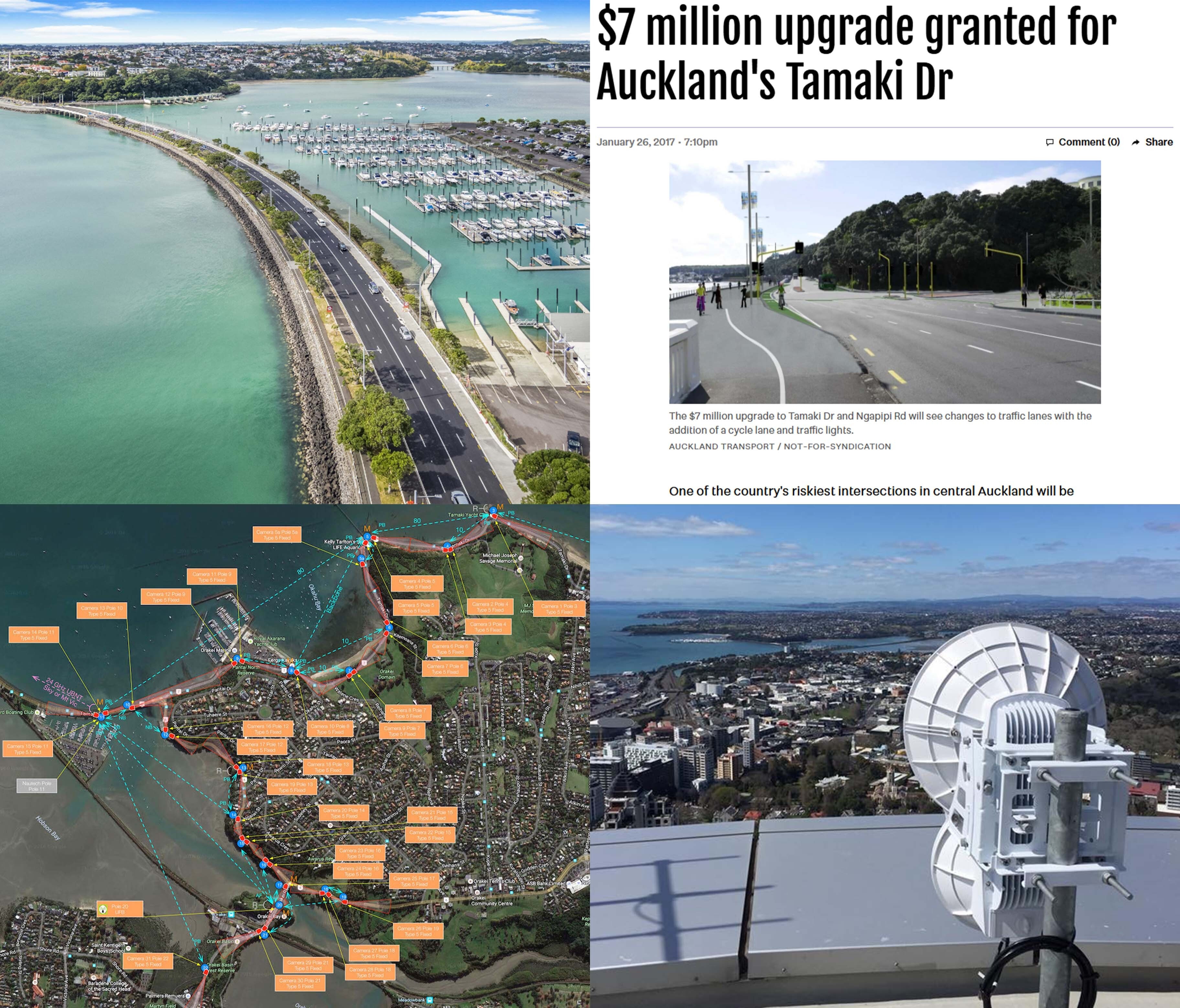
The intersection of Tamaki Drive and Ngapipi Road in Auckland’s Orakei was ranked as having the 10th highest crash risk in New Zealand.
Auckland Transport developed a safety plan to:
- Widen the intersection
- Add traffic lights and a cycle lane
- Improve signage and lighting
- Upgrade stormwater management
- Develop a future shared path to Glen Innes
However, with 30,000 vehicles using the intersection daily, locals were concerned the new $9m intersection would worsen traffic and increase journey times into the CBD. To accurately assess the impact, a detailed understanding of traffic flows before and after the changes was required.
SaferCities was engaged to develop a CCTV system to automatically record vehicle congestion and journey times approaching the intersection from all directions.
Why SaferCities?
Our expertise in building robust wireless CCTV networks in public spaces, combined with our end-to-end project management, ensured the successful deployment and ongoing utility of this key infrastructure.
What we did
In consultation with Auckland Transport and Auckland Council stakeholders, SaferCities developed a wide area CCTV network providing full coverage of vehicle movements along Tamaki Dr and Ngapipi Rd. The final design consisted of 31 CCTV cameras, with data being sent to AT's Video Analytics Platform, as well as six dedicated Automatic Number Plate Recognition (ANPR) cameras.
Due to the winding, seaside nature of the camera locations, a large and resilient network was required to connect all the cameras back to AT's datacentre. This required installation at 24 network locations, including a local Mission Bay business, 22 Streetlights and Auckland's tallest building, the Sky Tower.
A blend of 5GHz and 24GHz frequencies over point to point (PtP) and point to multipoint (PtMP) connections were leveraged to provide the optimal connection for each wireless link.
To ensure network resilience in case of device or streetlight failure, redundant network paths were built into the wireless network through dedicated fibre circuits at De Fontein and the Sky Tower to backhaul data to AT's network and Video Management System.
As well as industry standard subnetting and VLANs, OSPF and BGP routing were built on top of this, with routers at key network locations to allow network traffic to automatically route out the best path and self-recover from failures.
At the time, this was the largest wireless CCTV network deployed in a public space in New Zealand, and the network is still in service today.
In addition to the design, SaferCities oversaw the configuration and installation of the network, coordinating AT's field services contractors, streetlights team, traffic management, video analytics team and third-party stakeholders.
Results
This system provided valuable insights into traffic flows and modes before and after the intersection upgrade, and has been used to communicate the impacts accurately to the community and optimise traffic light timing in the area.
Auckland Transport Operations Centre (ATOC) still use the CCTV network to monitor and manage incidents and special events along Tamaki Drive.
Learn More:
Services
- Requirements Documentation
- Future State Recommendations & Design
- Project Governance
- CCTV & ANPR Cameras
- 37
- Network Nodes
- 24
- Daily journeys analysed
- 30,000